
Palouse to Cascades trail
- Chris Toepker
- Jun 11, 2021
- 2 min read
Updated: Sep 25, 2021
By now you’ve noticed - I really enjoy running rails to trails. It’s the way they wind through so much, connecting it all. The rails are dead; long live the rails!
Likely, you have a bunch in your area too, thanks to "rail banking." Here's a guide and review for easier enjoyment of the Pacific Northwest rail-trails, and maybe a little inspiration to check out those nearest you!
So, using the 1920s US Department of Transport rail map of Washington below...
Check out these major corridors around the region!
East Sammamish Trail(s) [One on each side of Sammamish river then along east side of Lake Sammamish to Issaquah]
Issaquah- Preston trail (aptly named for the rail line it totally follows).
Cascades to Palouse Trail (formerly Iron Horse trail)
A focus on the Cascade to Palouse trail (to Snoqualmie Pass)

5. Cascades to Palouse Trail
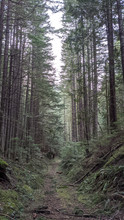
This trail was formerly known as the Iron Horse and/or the John Wayne Trail. However, as it leaves Rattlesnake lake (connecting through the prohibited forest to Cedar River trail), it stretches all the way across Washington. And, in some form or another, all the way to Chicago. Indeed, evidence remains - mile markers listing the distance back east!
The Snoqualmie Valley trail dumps into the King county Rattlesnake Lake recreation area parking lot. Continue to follow the road or trail along, away from the lake, and you'll find the State Park trail head. Follow the signs a short ways, and soon you're on the old Milwaukee road, at Cedar Falls, headed east (and up - to Snoqualmie Pass).
Again turn to the 1920s map, and check out places like Ragnar. You can see remnants of the railway storage and (de) construction in the form of old timber, ties and signal stands. Of course, at the top is the famous tunnel that goes under the peaks. While you can continue onwards from there, our training hasn’t yet taken us that far. Soon enough, I’m sure!
The trail starts at Cedar Falls, stretching 18 miles to Snoqualmie Pass.
This clip take you to Ragnar...
Around the corner from Ragnar is Garcia. This clip picks up there, going to Carter Creek.
Then, from Carter Creek all the way, finally reaching Hayek after going through the famous Snoqualmie Pass tunnel (2+ miles of discombobulating dark).


Commenti